
Today is 10th September which is Gibraltar National Day and I wanted to mark the occasion with a special blog post. As our family moved back to the UK this summer after over a decade in Gib, it will be a strange National Day for us. It will also be a ‘different’ one for the people of Gibraltar as this year, the traditional rallies and gatherings have been cancelled due to Covid-19.
This is my tribute to Gibraltar on National Day 2020, a post which I hope, will show my deep affection for the Rock and it’s people. It’s a place which will be forever in my heart, and I dearly hope I will be able to return to frequently in the years to come.
Way back in May, before we made our epic move back to the UK, I got the chance to do something I’d never done before…. walk the whole way round the Rock. It’s not something I’d done before because it takes quite a while and strictly speaking you aren’t allowed to walk through one of the road tunnels to complete the route.
However, during the waning weeks of lockdown while there was very little traffic on the roads many people were walking through and the authorities were turning a blind eye. Being someone who doesn’t like to bend the rules very often, I saw this new development as my opportunity and took it. (FYI it’s very busy on the roads again now, so I really wouldn’t recommend doing it now. PLEASE BE SENSIBLE AND DON’T WALK THROUGH).
Here goes…

I began my walk in South District not far from where we used to live on the (normally busy) Europa Road.

Past the beautiful blooms of bougainvillea and nasturtiums.

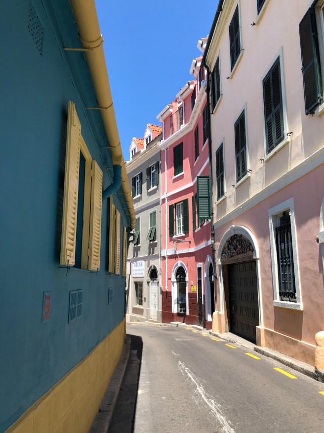
Rather than going the long way around via Queensway or Main Street, I walked above the Trafalgar Cemetery and popped through Prince Edward’s Gate and into Gibraltar’s old town that way.


And into town…


I walked along pavements I have walked countless times before over the years. It was strange to think that just a few weeks later, we would be saying goodbye to Gibraltar after 11 very happy years. During that time these streets, which once felt so alien and unlike where we had come from, became our home.

I passed below the beautiful and historic Garrison Library.

…and further on into town along the narrow Governor’s Street north towards Casemates Square.

As you can probably tell from the bright blue skies in the photos – it was a rather warm day!
In the north east corner of Casemates is a tunnel which leads to…

… Landport Tunnel which was, once upon a time, the only way to access Gibraltar by land. All the area beyond the city walls was once sea before a series of land reclamation projects were undertaken. At curfew each evening those big wooden doors would be closed and the drawbridge on the other side would be lifted sealing inhabitants of the Rock inside for the night.

The tunnel is steeped in history – walking through it you can imagine some of the people who must have come through here over the centuries. There is a bend in the middle for defence purposes I believe.

As you come out of Landport Tunnel Gibraltar’s military heritage is in evidence on your right and above your head lies the Northern Defences – a place I would have loved to explore before we left.

Onwards and northwards I headed towards the airport and the sundial roundabout.

My path turned to the East at this point along Devil’s Tower Road.

This road (which is normally very busy but thanks to lockdown was extremely quiet) has a mix of older housing blocks, flashy new developments and industry. The Rock looms above it all.

At Eastern beach you pass the local vehicle licensing and MOT test centre, behind this military pill box.
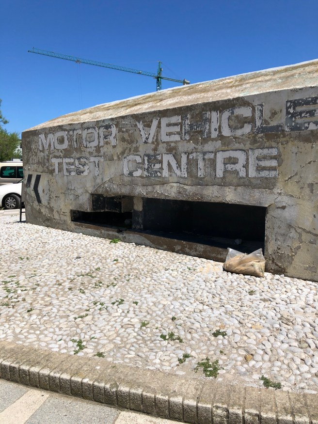

As I passed by this spot I was rather taken by this little chap!


There are plenty of reminders on the East side of Gibraltar’s military past as well, apart from the spy holes in the Rock above your head is this cairn constructed in memory of the members of the Black Watch who worked here to create some of Gibraltar’s Defences. I wonder what they thought about the heat of the Med after traveling down from the Highlands of Scotland?!


The sun was rather intense at this spot beating down on my head (I’m glad I wore a hat!) and the crickets were chirping in the grass by my side.

All of a sudden after the industrial buildings the developments give way to a huge land reclamation project and on the other side – beautiful Catalan Bay. When we first arrived in Gib, this was our beach of choice in the summer. It’s small-ish and is less easy to lose children when you take your eyes off them for a millisecond! Plus there is ample parking if you arrive early enough in the day. Lately though, we moved to Sandy Bay which is a lot less densely populated and gives you much more space.
Beach protocol in Gib is something which you quickly learn as a newcomer to the Rock. Local families have their traditional pitches where they always set up camp on the beach and it can be quite easy to ruffle feathers if you plonk yourself down in a seemingly empty spot. At the height of summer beach umbrellas, deck chairs and tables appear on the beach at first light many hours before their owners appear to take up residence. It is quite a sight to behold.


Rather than dashing down to the beach to feel the sand and waves on my toes I kept on going along Sir Herbert Miles Road which hugs the back of Catalan Bay village (Sir Herbert Miles was Governor of Gibraltar from 1913-1918).

Catalan Bay was once solely populated by ex-pat Genoese fishermen and their families. Until about 100 years ago the village was cut off at high tide and the only access was via the beach when the tide was low. Genoese was the language spoken here and Caletaños (Catalan Bay villagers) are responsible for a lot of the Genoese words which have become a fixture in the Llanito dialect in Gibraltar.

Traditional wooden boat building is still a skill which is passed down through the generations in this village. The beautiful handcrafted rowing fishing boats are used daily by village fishermen to catch fish, they are also used for a traditional annual boat race in the Bay.

Along Sir Herbert Miles Road is the pretty and colourful development of Little Genoa (can you see what they did there?).

All the while the huge Rock is there above you!
After Catalan Bay is Black Strap Cove, a small stretch of undeveloped land between Catalan Bay and Sandy Bay. As with much of the Gibraltar coastline you can see now abandoned military installations amongst the rocky cliff side. It is a haven for wild flowers in spring and I’ve seen Barbary Partridges here at times too. A lovely spot.
Next stop Sandy Bay…

When we first arrived in Gibraltar 11 years ago, there was a tiny pebble beach here at Sandy Bay. The winter before we arrived brought tremendous storms and sea swells and washed the beach away (as well as running a huge tanker aground by Europa Point and causing damage elsewhere in Gibraltar). Maybe 5 years ago (my memory may be wrong here) the Government completed the project to build a couple of groynes to protect the beach and shipped in tones of sand to replace what had been lost in the storms.
Sandy Bay is now a large beautifully sandy stretch of beach and thanks to the rocky arms stretching out to hug the beach, the water here can be calm where the conditions are choppy elsewhere for swimming. The perfect spot to spend a day with the family! It’s now our beach of choice.

The housing development of Both Worlds which forms a barrier between the main road and the beach was built just over 50 years ago and opened just around the time the border between Gibraltar and Spain was closed by General Franco. Overnight Gibraltarians couldn’t cross over for holidays and trips into Spain, and Both Worlds became a holiday destination for many local people.
When it opened there were shops here, food delivery services (much like what many of us rely on these days) and even a mini buggy taxi service which would give residents a lift along the length of the resort. I happened upon a fabulous newspaper supplement advertising the new Both Worlds development in a 50 year old Gibraltar Chronicle at the National Archives a while ago. It made for fascinating reading!
It is now a residential block, half of which is for over 50s and the rest is sold on the open market. Some of the apartments can be rented as holiday lets.


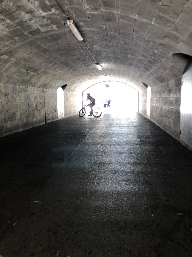
A short way south of Sandy Bay is Dudley Ward Tunnel. This is the tunnel which isn’t supposed to be used by pedestrians but during lockdown became a regular pedestrian route around the Rock because of the greatly reduced traffic on the roads.

Goodbye sunshine… into the cool darkness. I had my fluorescent gear on so I could be seen clearly walking along the side of the road (fortunately just two cars passed me by). I didn’t hang about for long, it felt very naughty to be in there. I don’t mind telling you that was a bit relieved when I popped out into daylight at the other end!

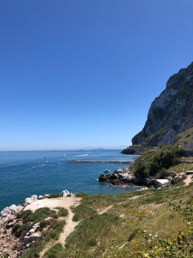
The coastline here is different to the other end of the tunnel, the cliffs are steeper and go right down to the sea below.

You get a clear view of the clay pigeon shooting range which was built for the Island Games last year.

This section of the Rock is protected as a UNESCO World Heritage Site. In the photo below you get a true sense of the magesty of the cliffs looking northwards. Down at just above sea-level is the Gorham’s Cave complex which is full of important archaeological research.

It truly is a beautiful spot.

When I could see the lighthouse at Europa Point, I felt like I was on the final leg of my journey. Not long now before I could have a cold drink and a sit down!

Out at sea, as I was walking, I spotted a bit of argy-bargy between a Guardia Civil boat and a Royal Navy rhib. That’s a common sight round these parts as there is an ongoing dispute about who the British Gibraltar Territorial Waters actually belong to. Sometimes skirmishes make the British news, one day I saw a flare being fired by the British after a Spanish vessel continued on a collision course towards a submarine. That was quite a sight I can tell you!

Onwards in the full heat of the sun heading south…

… there she is – Trinity Lighthouse. Doesn’t she look magestic?

The lay-by which offers this stunning view also has a touching memorial for a young soldier.

As you round the bend in the road, in front of you is the dramatic sight of the Mosque.

Between the mosque and the lighthouse, Europa Point is a rather iconic part of the Rock. It’s also home to a fabulous play park for young children, a heritage information centre, Gibraltar University, the Shrine of Our Lady of Europe and the recently built Europa Point stadium which is home to Gibraltar Rugby & Gibraltar Cricket and was used to house the Nightingale facility to cope with Covid-19 patients (although, so far, thankfully, it hasn’t needed to be used).

The road swings round to the north again after Europa Point offering great views of the Rock.


Looking westwards out to see you see both the Moroccan coast (on the left of the photo below) and the Spanish coast (on the right) the strip of water between them is the famous Strait of Gibraltar and the gateway to the Mediterranean.

Europa Road here gets quite narrow as it was once crossed by an archway and policed by an army sentry.

It was a defence point to stop invaders approaching from the south getting access to the town.

And finally I had reached my destination… almost home, I was back in South District!

Two hours on from when I’d set off, I had completed my circuit of the Rock. I am so pleased I managed to tick this walk off on my to-do list in Gibraltar. Despite living there for over a decade, there are still some things I didn’t manage to achieve, like visiting the Lower St Michaels Cave and exploring the Jungle and the Northern Defences. I hope one day I will be able to do those things.
In the meantime, when I’m in my new home in the UK I have some truly wonderful memories of our time in Gib, and feel truly blessed that we had our time there, and that the Little Postcards could enjoy some of their childhood there too.
Thank you Gibraltar and happy National Day 2020! 🇬🇮
Lindsay x

Oh Lindsay this was an amazing post for National Day and made me shed a tear. So beautiful! Thank you and if you don’t mind I will try and share it, as I think Gibraltarians abroad would love it too xxxxx
It’s my pleasure Marisa, so glad you enjoyed it. I thought of you & your Mum as I walked past her estate! Happy National Day xxx
Thank you,
I have just spent a lovely hour walking around Gibraltar with you. I lived on Europa road for 4 years from1946 when my father was in the army. Of course, it was very different then but it all comes back to me.
The house we lived in, overlooked the bay, but years after we left they built a block of flats in front of it, apparently, but I do remember a building that was a Catholic church about a hundred or so yards from hi and I wonder if it is the one in one of your photos of Europa road with a red car on the left.How ever thank you again,I still have such lovely memories of the happy times I had there.
Very best wishes
Pat Matthews.
Hi Pat, thanks so much for this lovely comment. It’s amazing how many people have a connection to the place through the forces. I’m so glad you enjoyed the virtual trip! St Bernard’s church is on the right of the photo on Europa Road with the red car parked on the left. It is very close to the accommodation where many forces families used to stay, so you are most probably correct. As the number of forces families has reduced so greatly, many have been housed in new accommodation right next to the airport at Four Corners these days. Thanks again for getting in touch! Lindsay 😊